Thailand and Cambodia have been locked in a border dispute for more than a century, which exploded again in the summer of 2025. Peace efforts have had mixed results and fighting continues.
A historical dispute over lines drawn on colonial maps is often used as a pretext for simmering nationalism. The two countries have had what one historian called a “sibling rivalry” for decades, fanned by competing claims to the region’s rich cultural heritage, including ancient temples in disputed areas.
Competing territorial claims date back more than a century, when France occupied Cambodia, which was part of French Indochina.
Compared with today, the border between Thailand – then known as Siam – and Cambodia – then part of French Indochina – lay further to the south. As a result, Cambodia was smaller than it is now.
Beginning in the early 20th century, a series of Franco-Siamese treaties pushed the frontier northwards and expanded Cambodia’s territory. The 1904 treaty first redefined parts of the border, using a natural ridge-line as a key geographical marker.
A subsequent 1907 treaty delivered a more substantial shift, with Siam ceding the provinces of Battambang, Siem Reap and Sisophon to French Indochina. These agreements helped establish much of the modern Cambodia-Thailand border and significantly expanded Cambodia’s territory to the north and north-west.
This means that the border region is now dotted with ancient Khmer stone temples that are cherished by both sides.
Moving the border north to follow the Dangrek escarpment – a ridge-line that also runs alongside a watershed dividing river systems flowing into Cambodia and Thailand – meant that several important temples came to lie close to the border.
But the treaties left their exact ownership open to interpretation with different historic maps being referenced by both sides.
This means that three disputed temples run along this disputed escarpment: Prasat Ta Moan Thom, as it is called by the Thais; in Khmer, it is Ta Muen Thom; Prasat Ta Khwai (Prasat Ta Krabey in Khmer) and Preah Vihear.
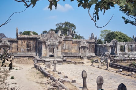
While all three are disputed, Preah Vihear has long been the focal point of the dispute. The 11th century Hindu temple, known as Khao Phra Viharn in Thailand, has been controlled at different times by both sides. The temple pre-dates Cambodia’s more famous Angkor Wat temple complex by 100 years. It sits on the edge of the escarpment.
The modern dispute stems from a 1907 French-produced map, known as the Annex I map, which placed Preah Vihear on the Cambodian side. This contradicted the Franco-Siamese treaty’s instruction that the border follow the natural watershed of the Dangrek range.
Shane Strate, associate professor at Kent State university, Ohio, who specialises in south-east Asian history, said that the boundary line on the map was largely drawn along the watershed. Yet when it reached Preah Vihear, “it veers off course to enclose the ancient temple within French colonial territory before returning to the watershed line once again”.
The Annex I map shows a hand-drawn border line (marked with crosses) running north of the ridgeline but south of the watershed.
Siam did not formally object at the time, but the map’s deviation later became central to rival sovereignty claims. During the second world war, Siam briefly occupied the temple before relinquishing control.
Tensions resurfaced after Cambodia gained independence in 1953, leading to a legal case at the world court, the UN’s international court of justice (ICJ). The ICJ decided in 1962 that the temple itself belonged to Cambodia.
The fact that Siam did not formally object to the Annex I map in 1907 underpinned Cambodia’s 1962 victory at the ICJ.
However, the ruling failed to clarify the ownership of the larger contested area around the temple, resulting in arguments persisting until today.
The dispute turns on Thailand’s argument that the border should follow the watershed line referenced in the original Franco-Siamese treaties, even though those agreements did not include detailed maps defining it. Keeping surrounding territory would allow Thailand to maintain easy road access for tourists, who have previously visited the temple via the Thai side.
Thailand maintains that the watershed puts Preah Vihear and nearby territory on its side of the frontier, in conflict with the 1907 Annex I map used by Cambodia to assert its claim.
The map below shows the complexities of the varying claimed boundaries around the temple.
With Thailand and Cambodia continuing to rely on differing historical documents and interpretations of the same rugged border, Preah Vihear and its neighbouring temples are likely to remain flashpoints.
Chris Baker, a historian based in Thailand, said older maps and treaties were often exploited by neighbouring governments that have competing political and economic agendas.
“While the varying maps are in existence and can be invoked in these disputes, I don’t think this dispute is about the border,” said Baker.
“The other factor is the longstanding sibling rivalry of the two countries, so fierce precisely because they are so similar.”