 3 hours ago
4
3 hours ago
4
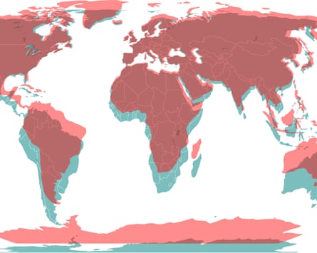
This month, the UN passed a resolution, brought to the assembly by Togo, to phase out the traditional Mercator map of the globe and replace it with another that shows the real scale of territories. That’s right – when it comes to size, the map of the world we have all grown up with is not accurate. The main loser of land on the Mercator map is Africa, and the new “Equal Earth” map reflects its true proportions. I spoke to our west Africa correspondent Eromo Egbejule about his extensive reporting on the map changes, and why people feel so strongly about it.
Seeing the new map transposed over the old might make you feel oddly disoriented. Logically, there is absolutely no immediate tangible impact on one’s life that comes out of knowing that the entire top part of the northern hemisphere is so much smaller than you were led to believe. And yet, there is still something agitating about it, like you’ve been the subject of a lifelong trick, or at least a breach of trust.
The vast geographical inaccuracies of the old map include the shortening of Africa, and the relative expansion of North America and Eurasia. The new projection shows Africa as taking up almost double the ratio of total land area shown on the map. It all feeds into a sense that there is something domineering about it, portraying some countries as not just political and economic powers, but geographical ones as well, and therefore natural hegemons. It is an emotional response more than anything, but a testament to how much our perceptions of the physical world are linked to our estimations of stature.
No, the world map has not gone ‘woke’
The Guardian’s west Africa correspondent Eromo Egbejule is struck by how, despite its disproportionality, there was still opposition to retiring the 16th-century map. The US was the only country that vetoed the UN resolution, and six other nations abstained. The US dismissed the effort as “superfluous”, but Eromo sees this as a euphemism for “ideological” or “woke”. “I don’t see why it feels so strongly,” he told me. “This is a scientific discussion. It’s not an imposition.”
There is nothing binding about the resolution, and yet, there is something revealing about the world’s superpower opposing it. It suggests that the US would like to preserve that connection between size and status, even when appearances are deceiving. US president Donald Trump’s interest in Greenland was reportedly influenced by its inflated size on the old map, an acquisition that would swell US territory in the political imagination. Greenland is “massive” said Trump – but in actuality, it’s a fraction of its size as shown in the Mercator projection. The old map depicts it as roughly the same size as Africa, despite it being 14 times smaller. Could huge geopolitical tensions, and confrontation with Europe, could have possibly been avoided by simply showing Trump an accurate map?
Do maps really matter?
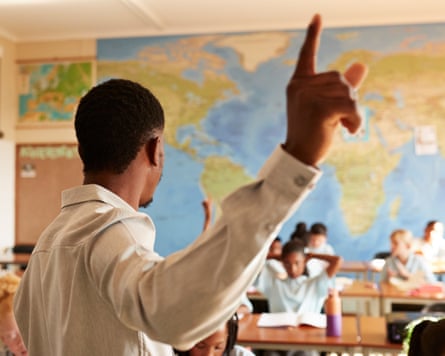
“It does matter. Make no mistake,” said Eromo. In his view, the significance is in the momentum such a resolution triggers. “There’s two proverbs we have in pidgin,” Eromo said: “every dance begins with a clap” and “it’s grains of rice that fill up a pot”. In other words, this might feel like a small change, but the boost of one successful campaign could pave the way to what Eromo describes as a “multipolar world order”. He points out that this resolution comes on the heels of a separate landmark one – the UN vote to recognise the transatlantic slave trade as a crime and call for reparations, an effort also led by an African country.
There is a growing traction around a particular kind of advocacy: one that uses the procedures of high-profile international institutions to challenge dominant western understandings of history and reality. These interventions in how we make sense of the world may be symbolic – but they are meaningful, and they are gaining ground.
Moving towards a shared reality?
after newsletter promotion
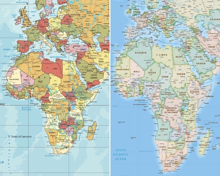
It is staggering that the Mercator map has pretty much remained the unchanged standard for over four centuries. In questioning what was once assumed to be fact, the resolution has not only addressed issues of accuracy. It has also, somehow, punctured the vast and abstract unrealities established throughout history by the west. The theft of resources and people is only one part of what was stolen from many regions of the world during colonisation. Countries were then stolen from, again, in terms of landmass on maps, and also the subordinating cultural and political associations that followed. There is something intangible and deeply political about the map’s significance – which is symbolic and threatening.
Eromo said that this sort of change makes people nervous because it ties in to all the ways in which legacies of literally carving out the continent and enslaving its populations still resonate. Hanging over the resolution are questions of precedent, of the floodgates being opened – the sort of building pressure that has resulted in calls to decolonise curriculums, for example. If the map that hangs in classrooms all around the world is changed, people may ask: “What else are my children going to be taught now?” Eromo said that there is something diminishing about learning that behemoths such as the US, China and Russia “can all fit into Africa with some space to spare.”
There are broader anxieties at stake – about what constitutes our shared reality, one that is increasingly fractured by social media and AI. These make tussles about maps a matter of holding on to the little that we can establish as concrete and true, in the face of vast political and digital forces that are warping our perceptions of the world. Eromo cites a statement that stood out for him, issued by Africa No Filter, an advocacy group that has been a part of the map justice campaign: “If we got something as basic as Africa’s size wrong for this long, what else about Africa have we simply accepted without questioning?”
Tap in
If you could bring a resolution to the UN related to the Black diaspora, what would it be? Send us your thoughts by emailing us at [email protected] or replying to this email and we may include your response in a future issue.