Temperatures plummeted this week across the eastern half of Europe, with the Alps dipping as low as -20C and to -8.5°C in the Polish town of Zakopane in the Tatras Mountains.
Heavy snow also affected other parts of Poland with 15-20cm (about 6-8in) of snow falling in much of the central swathe of the country and more than 40cm in the south towards the mountains.
This occurred as an area of low pressure moved up from the Balkans and collided with cold Arctic air over Poland. Due to the sheer amount of snowfall, 2,900 firefighter callouts were made and 75,000 homes in Rzeszów were left without power.
To add to the chaos, an Embraer E170STD aircraft, capable of carrying 80 passengers, veered off the runway on to a grass verge on a flight from Warsaw to Vilnius in Lithuania. Air traffic was delayed for several hours and the return flight did not depart.
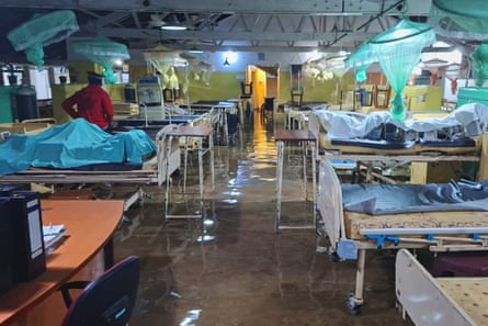
Extreme rainfall hit Sri Lanka this week. Sri Lanka typically receives between 250mm and 300mm (10-12in) of rain in November. In a 24-hour period, more than 250mm fell in many parts of Sri Lanka, which led to widespread flooding and more rain is expected in the coming days.
Up to 425 homes have been damaged by mudslides, 1,800 families are being housed in temporary shelters, 40 people are dead and 10 injured. Eighteen of those who died were from the mountainous tea-growing regions of Badulla and Nuwara Eliya, 300km (186 miles) east of the capital, Colombo.

The unique topography of the area increased rainfall by a process known as orographic enhancement. As clouds are forced to rise over mountains, the air begins to cool. When the air cools enough, it reaches its dew point and condenses. As a result, orographic clouds form. The continuous ascent and condensation lead to the formation of cloud droplets. Preexisting rain from higher-level clouds falls through the newer, lower orographic clouds and binds together by a process called accretion. This process makes each rain droplet larger, hence higher rainfall totals in mountainous areas.