The homes of people in Nunsthorpe, a postwar former council housing estate known locally as “The Nunny”, sit only a few metres away from their more affluent neighbours in Scartho with their conservatories and driveways.
Walking between the two is almost impossible because of a 1.8-metre-high (6ft) barricade between them, which blocks off roads and walkways that link the two areas in Grimsby, Lincolnshire.
Journeys that should only take a few seconds become a 25-minute walk down to the open field on the edge of the estate, or through the grounds of a hospital, to bypass the wall.
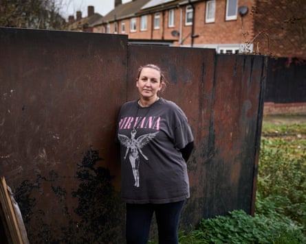
“It’s the posh-poor divide,” said Serenity Colley, 37, who lives on the Nunsthorpe estate with her partner and children. “It has been there for as long as I’ve known, since the new estate was built. I don’t think they’ll bring it down because I don’t think they’ll want to mix with us. In some ways I don’t blame them because they are spending a lot of money on those houses, they want to protect what they’ve got.
“There’s a massive gap and it’s blatantly obvious.”
A Guardian analysis of figures from the Ministry of Housing, Communities and Local Government – looking at the most and least deprived 10% of areas in England – reveals how deep inequality can run, sometimes across nothing more than a few metres of asphalt, a line of hedges or, in this case, a 6ft wall.
Years of austerity and underinvestment mean almost two-thirds of councils now contain a neighbourhood that ranks as one of the most deprived in the country, compared with just under half in 2004. As deprivation has become more geographically widespread, there has been a stark increase in the number of places where deprived and affluent people find themselves living side by side.
One possible reason for the rise is the creation of new-build housing estates on the outskirts of towns, next to existing social housing. But the growth is also partly due to the collection of additional data with the intention of giving a truer picture of the spread of deprivation across the UK. Dr Mark Fransham, a senior lecturer at the department of social policy and intervention at the University of Oxford, pointed to the fact that high housing costs are now factored in to the analysis, a change that could reveal more deprived areas close to affluent ones.
In 2019, just 65 of the most deprived neighbourhoods bordered one of the least deprived neighbourhoods. That rose to 119 in the latest data, released in October.
A majority of the latest “deprivation divides” were found in the north of England – though new faultlines also appeared across London and the south.
In Grimsby, the divide between the neighbouring areas is the biggest in the country, and starkly apparent. The wall next to Nunsthorpe is much more than a symbolic divide, it means a longer journey to the new Aldi supermarket, to some schools and to a care home that is a key source of work for many of the people who live on the estate.
“Our school run takes an hour – if I could just go through then it would take 15 to 20 minutes,” said Colley. “And if you have a car on this estate, you are actually quite lucky to have that car, so lots of people try to jump over it.
“It also attracts antisocial behaviour and people throw rubbish over it. You get a lot of young kids congregating, throwing glass bottles about. You get people doing drug deals there in the middle of the night because they can just hide in the corner.”
Others on the street agreed, saying the wall created needless division, with rubbish getting thrown over the wall from both sides of the divide.
“I feel like they think we’re the lower end and they’re the posh end. You try to have a nice house and nice garden, and then you live opposite that,” said one of Colley’s neighbours, gesturing towards the rusted metal wall.
On the other side, people seemed unaware of the issues the wall raised or reluctant to talk about it – the layout of the houses meant the wall was much more hidden from view.
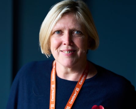
At Centre4, a community centre sat in the heart of the Nunsthorpe estate, staff were keen to stress that they helped people from across both sides of the divide.
“Your postcode doesn’t necessarily indicate your level of challenge,” said the charity’s chief executive, Tracey Good. “You can struggle financially and you can be a victim of domestic abuse even if you live in a nice house. It doesn’t mean to say you’re not struggling to raise your family or pay your bills or with your mental health and feeling isolated.”
But many of the people Centre4 helps do live on the Nunsthorpe estate, and it is why the charity is in the process of building a new youth centre after years of facilities being stripped away. Some of the local teenagers said they thought the plans looked “too posh for them”.

The charity is inundated with requests for financial advice sessions – it opens weekly slots at 9am on Monday that are fully booked within 15 minutes – and a growing number of people are approaching it at crisis point, sometimes with carrier bags full of unopened bills or 10 years’ worth of council tax arrears.
Nunsthorpe is in the most deprived 10% of areas for income, employment, education, health and crime, although ranks highly for housing quality and air pollution – it was built on the garden city principles with lots of green space, and the housing stock was largely built for war veterans.
Meanwhile Scartho, on the other side of the wall, ranks among the least deprived 10% of neighbourhoods overall, and is in the top 20% for employment, health, low crime, and environment.
Good said that although the Nunsthorpe estate still struggled with high levels of crime, there was a fierce loyalty and sense of community among its inhabitants that meant many of them enjoyed living there.
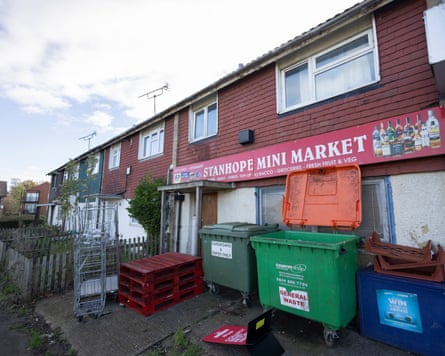
People felt similar on the Stanhope estate in Ashford, Kent. A 1960s London overspill estate once nicknamed “No Hope” because of its high crime rates, it has undergone some regeneration in recent years, but is in the 10% most deprived neighbourhoods in England.
It has had a large rise in health deprivation since the pandemic, relative to other areas, and also ranks among the most deprived 10% for education and crime.
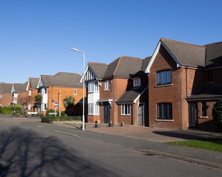
Stanhope is closely bordered by spacious detached homes built in the early 2000s that sit in the top 10% for employment and living environment, and the top 20% for income and health.
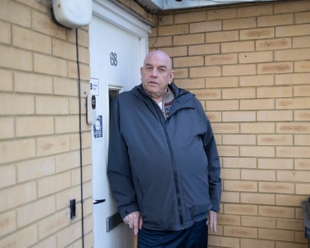
“They might have bigger houses, but here there’s more community,” said Phil Hockley, 63, who has lived on the Stanhope estate for 16 years.
“You’ll probably find a lot of people over there don’t even speak to each other. And who wants a £350,000 house and a massive mortgage around your neck? But a lot of the new properties in this area are for people coming over from London anyway.
“They’re not looking at people who actually live in the area.”
On the Stanhope estate, an average three-bedroom house sells for about £275,000 – across the divide, they go for about £410,000.
One person who lived just outside the estate, and asked not to be named, said that when he moved to the area, he was specifically told to avoid Stanhope because of its “bad reputation” and to buy outside the “ring” – which marks the line of the deprivation divide.
Susan Riley-Nevers, 56, a Stanhope resident who works in holistic health, said there was concern the housing disparity was fuelling division and resentment, and contributing to the sentiment that had led England flags to appear all over the estate.

“This part of the community is neglected. But if I lived 10 minutes up the road and I said: ‘Oh, we need some road humps,’ that’s a priority,” she said.
There were many ways in which the division was felt on the ground, Riley-Nevers said, the GP surgeries nearest to Stanhope were oversubscribed so it was difficult to get an appointment, but those in other areas had more capacity.
“Over here our amenities have slowly been taken away, and most of the community problems here are to do with poverty,” she said. “It’s a very different story in other areas.”